Sentinel-5p TROPOMI provides two SO2 data products:
Sulphur dioxide total column and sulphur dioxide layer height. For both validation results in the latest ROCVR are available.
The Sentinel-5p TROPOMI L2_SO2 sulphur dioxide column data are found in general good agreement with ground-based MAX-DOAS and PGN measurements and with other satellite observations from OMI and S-NPP OMPS. The bias and dispersion with respect to validation data are typically below 0.2 DU. From these comparisons it can be concluded that over polluted regions the mission requirements are fulfilled. Over volcanic plumes the requirement on the bias is fulfilled, while the dispersion can exceed slightly the requirement on the random component of the uncertainty. In November 2024 the SO2 processor was changed to the COBRA algorithm (Theys et al., 2021). A reprocessing of the whole dataset has been set up and data was released in summer 2025. The dispersion and biases of the new version are substantially decreased compared to the previous version (Lambert et al., 2026).

References
Lambert et al., Routine Operations Consolidated Validation Report of the Sentinel-5 Precursor Operational Data Products #30: April 2018 - February 2026, https://mpc-vdaf.tropomi.eu/UploadDir/reports//pdf/S5P-MPC-IASB-ROCVR-30.01.00_FINAL_sJCL_AD.pdf
Theys, N. et al. A sulfur dioxide Covariance-Based Retrieval Algorithm (COBRA): application to TROPOMI reveals new emission sources, Atmos. Chem. Phys., 2021, 21, 16727-16744, doi.org/10.5194/acp-21-16727-2021doi.org/10.5194/acp-21-16727-2021
Theys, N. et al. Sulfur dioxide vertical column DOAS retrievals from the Ozone Monitoring Instrument: Global observations and comparison to ground-based and satellite data, J. Geophys. Res. Atmos., 2015, 120, 1-22, doi.org/10.1002/2014jd022657
The Sentinel-5p Mission Performance Centre provides an operational validation service relying on the VDAF Automated Validation Server (VDAF-AVS). This fully automated data analysis system collects correlative measurements from quality-controlled monitoring networks and compares them to Sentinel-5p data using community endorsed protocols. It outputs a suite of traceable quality indicators enabling users to judge the fitness-for-purpose of the Sentinel-5p data.
The illustration given hereafter shows the automated comparison of Sentinel-5p TROPOMI total SO2 column data with respect to correlative measurements aquired by a Pandora UV/Visible spectrometer of the Pandonia Global Network. More TROPOMI SO2 validation results are available at http://mpc-vdaf-server.tropomi.eu/so2 .
The VDAF Automated Validation Server in brief:
- hosted at BIRA-IASB and operated with s[&]t,
- provides routine validation for the ESA/Copernicus Sentinel-5p Mission Performance Centre,
- ingests correlative measurements from the ESA Atmospheric Validation Data Centre (EVDC) hosted at NILU, collected from ESA's Fiducial Reference Measurements (FRM) programme and from ground-based monitoring networks contributing to WMO's Global Atmosphere Watch,
- builds on heritage from the Multi-TASTE satellite validation system, the QA4ECV validation server (EC FP7 QA4ECV project) and the CAMS NDACC validation server (EC FP7 NORS project),
- is co-funded by ESA and the Belgian Science Policy Office (BELSPO) as a contribution to the Copernicus Space Component.
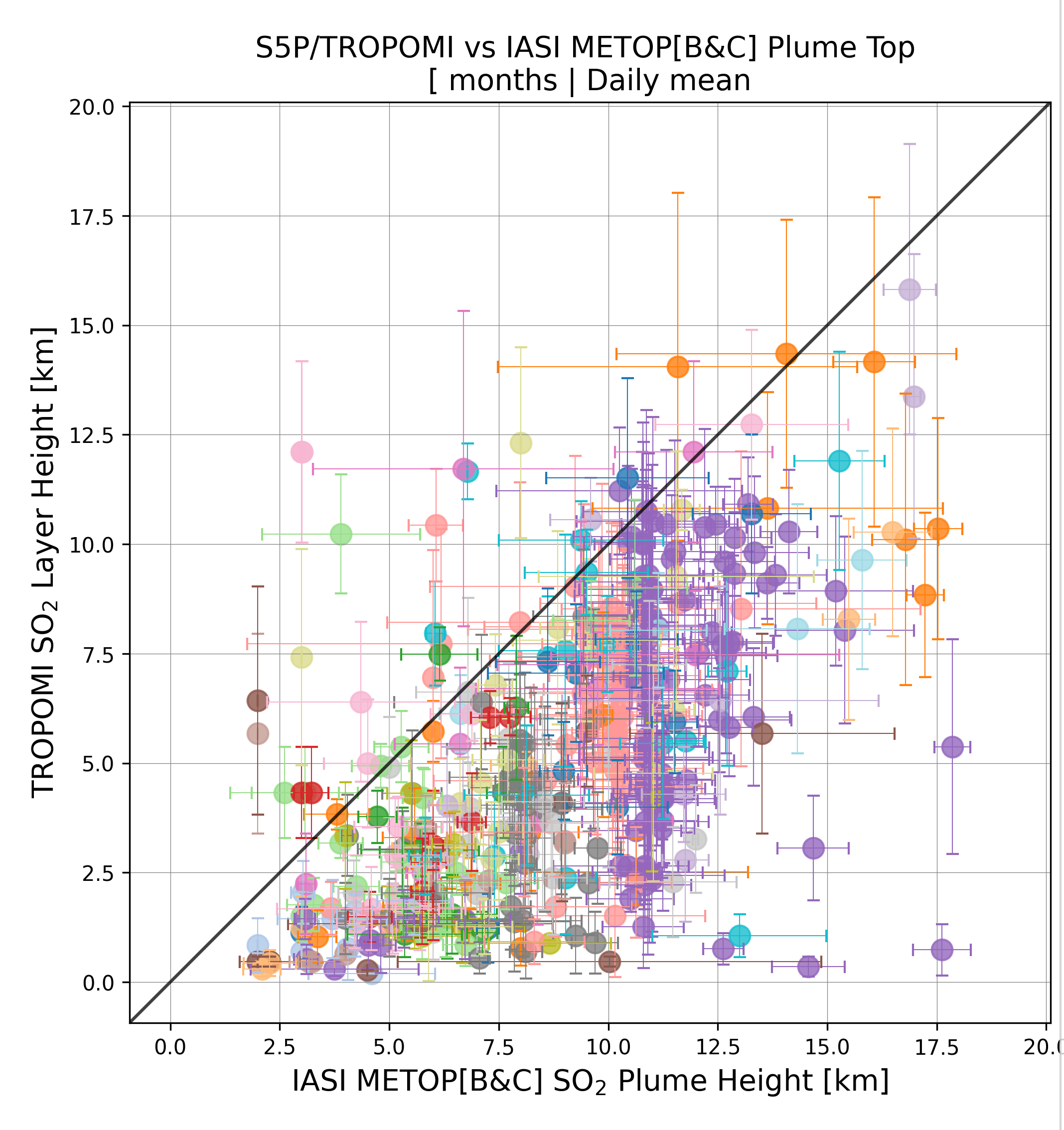
The validation of the S5P TROPOMI L2_SO2 sulphur dioxide plume height is based on satellite-to satellite comparisons, during large enough volcanic eruptions, with the Metop-B/C IASI “SO2_vertical_level” product, i.e., the retrieved vertical level of the SO2 plume, for the morning (AM) observations. Overall, TROPOMI shows lower SO2 layer height retrievals compared to the combined IASI/Metop[B&C] SO2 plume height observations by ~42 %, for both 2023-present (original validation) and 2018-present (RPRO) periods, equivalent to a mean SO2 layer height difference of ~3.2 km and ~3.5 km, respectively. HYSPLIT airmass forward/backward trajectories can be employed as a validation tool of the S5P TROPOMI SO2_Layer_Height observations and results usually indicate a good agreement between the height of trajectories and the height and location of the SO2 plume.
The figure shows the comparison between the daily mean TROPOMI SO2 layer height observations (y-axis) and combined IASI/Metop-[B&C] observations retrieved during volcanic eruptions of the May 2018 – August 2026 period.
Latest Issue
Quarterly Validation Report of the Copernicus Sentinel-5 Precursor Operational Data Products #31: April 2018 - May 2026
Archive
Previous issues of the quarterly validation report are archived here.